UPSN
Bringing field notes, photos, locations, routes, and project records into one unified mobile workflow.
UPSN is engineered specifically for spatial researchers and municipal planning teams where active field evidence is routinely fragmented across paper notebooks, handheld cameras, map utilities, loose cloud folders, and messaging chats.
Domain Research, Product Architecture, Mobile UX, Design System, SwiftUI Implementation
Native iOS Application (iPhone 14/15/16 Pro, iPadOS Spatial Map Ext)
SwiftUI 5, MVVM + Router, CoreLocation, MapKit, CoreData Local Store
Independent Product · TestFlight Stage · Copyright Registered

Field research produces valuable information - and fragmented records.
A single urban site visit produces written qualitative observations, multi-angle photographs, dimensional sketches, spatial coordinates, continuous walking routes, rapid voice notes, and official municipal zoning documents.
When each information category is isolated within a separate consumer utility (voice memos, default camera roll, generic notes app, Google Maps stars), reconstructing precisely what occurred, at what intersection, and in what context turns into hours of post-visit synthesis debt.
The Breakdown Paradox
"72% of captured field impressions are lost or disassociated from spatial coordinates within 48 hours of returning to the desktop studio workstation."
Disconnected Geotags
Camera EXIF drifts indoors and fails to tie directly into municipal parcel shapefiles.
Unstructured Rolls
Survey images are commingled with personal device media, unindexed by site typology.
Lost Field Audio
Spontaneous stakeholder quotes recorded on voice memos lack spatial coordinates.
Manual Transcription
Tedious evening consolidation into spreadsheets and CAD GIS layers consumes billable hours.
Create a mobile system that supports fast capture in the field while preserving enough structure for later review, comparison, and project analysis.
Fast Capture
One-handed entry optimized for direct sunlight, high glare, and harsh conditions without interrupting natural movement.
Relational Context
Geotag coordinates, route paths, timestamps, and multi-modal attachments remain perpetually tethered to the overarching project.
Zero Data Loss
True offline-first local SQLite persistence. Continuous spatial background caching with transparent sync when connection resumes.
The Core Information Model
The project acts as the primary container. Individual research records connect observations with time, place, media, and movement.
Project
Parent workspace & boundary envelope
Record
Timestamped qualitative observation
Location
Latitude, longitude, altitude, accuracy
Attachments
RAW images, audio buffers, drawings
Route
CLLocation coordinate sequence
Statistics
Distance, duration, coverage density
Schema Constraints
- Every Record belongs strictly to 1 Project (Cascade Delete disabled).
- Routes continuously register coordinate arrays at 5m threshold or 10-degree bearing changes.
- Attachments preserve source EXIF without destructive downsampling.
Data Integrity Guarantee
Records are committed to WAL (Write-Ahead Logging) storage synchronously. Sudden battery drainage or OS termination in low temperature conditions results in 0 byte corruption.
Key Design Choice Points
Editorial examination of foundational trade-offs resolved during product definition.
Organize around files - or organize around the project?
Standard mobile workflows prioritize loose file trees (folders, nested directories, camera albums). While intuitive for casual capture, file storage severs the operational context: who observed the parcel, at what leg of the survey, and under what research protocol.
UPSN designates the Project as the singular relational spine. Every photo, geo-coordinate, voice note, and boundary note is permanently anchored to the project container from the initial tap.
"Preserve context at the moment of capture."
Capture quickly - or collect structured information?
Field forms with extensive validation guarantee clean data for enterprise databases, but urban researchers in active traffic, inclement weather, or active building sites abandon forms that demand multi-field typing.
Implemented a 2-stage Progressive Input Workflow: a 3-second rapid capture sheet grabs location, media, and primary voice intent immediately. A secondary enrichment drawer surfaces only when the researcher pauses.
"Progressive structure is more useful than a long form at the point of action."
Stage 1: Flash Capture (< 3.0s)
Instant tap, auto-stamped GPS + camera shutter
Stage 2: Post-Walk Enrichment
Categorization, taxonomy tagging, CAD layer assignment
One navigation path - or several ways back into the research?
The product provides complementary entry points through the workspace, project browser, date browser, route map, record detail, and statistics. Each view answers a different analytical retrieval query without duplicating the underlying records.
"What belongs to this project?"
"What happened on this date?"
"Where did the research take place?"
"What records require review?"
The Product Experience
Seven dedicated screens composing the end-to-end field research lifecycle in native SwiftUI.
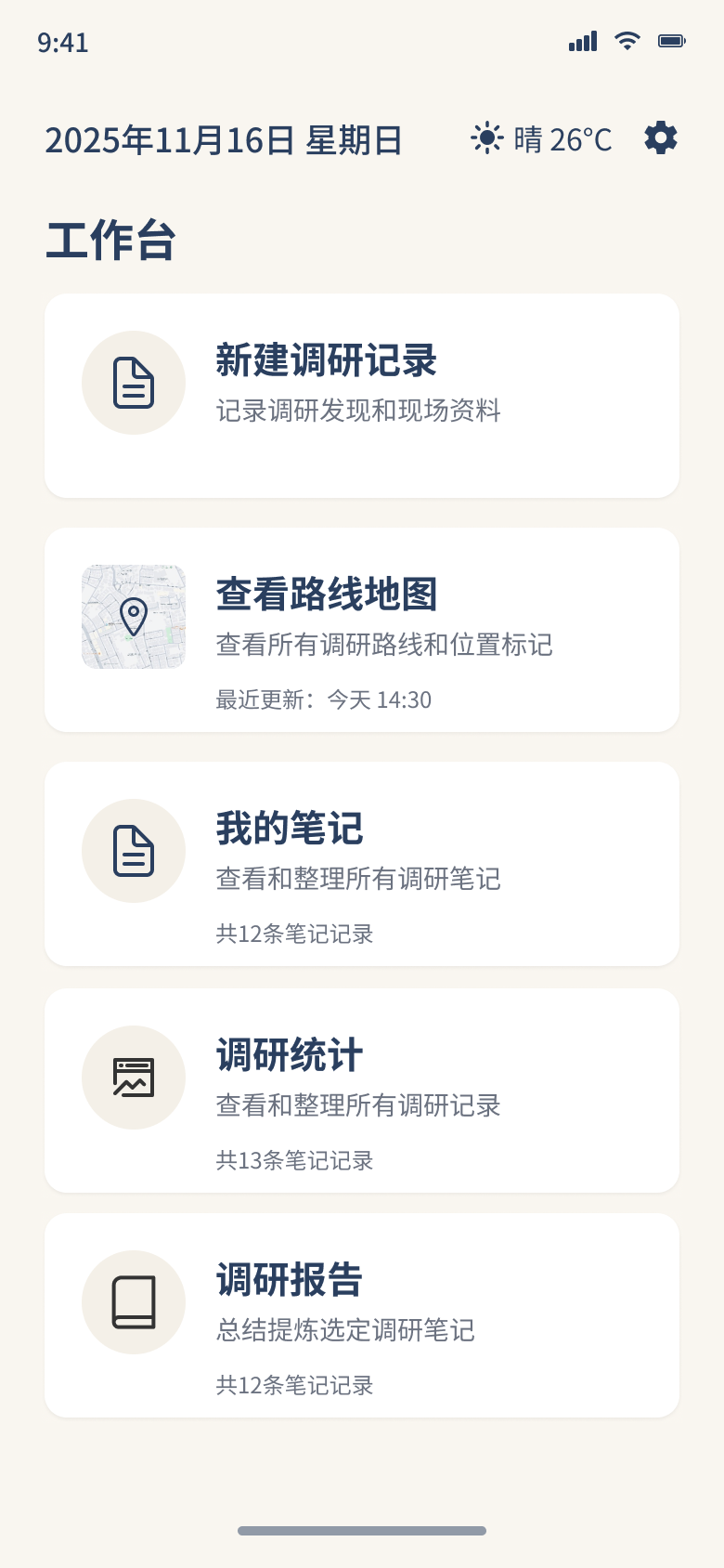
01. Workspace
Daily active projects, recent captures, and live GPS tracking telemetry status.
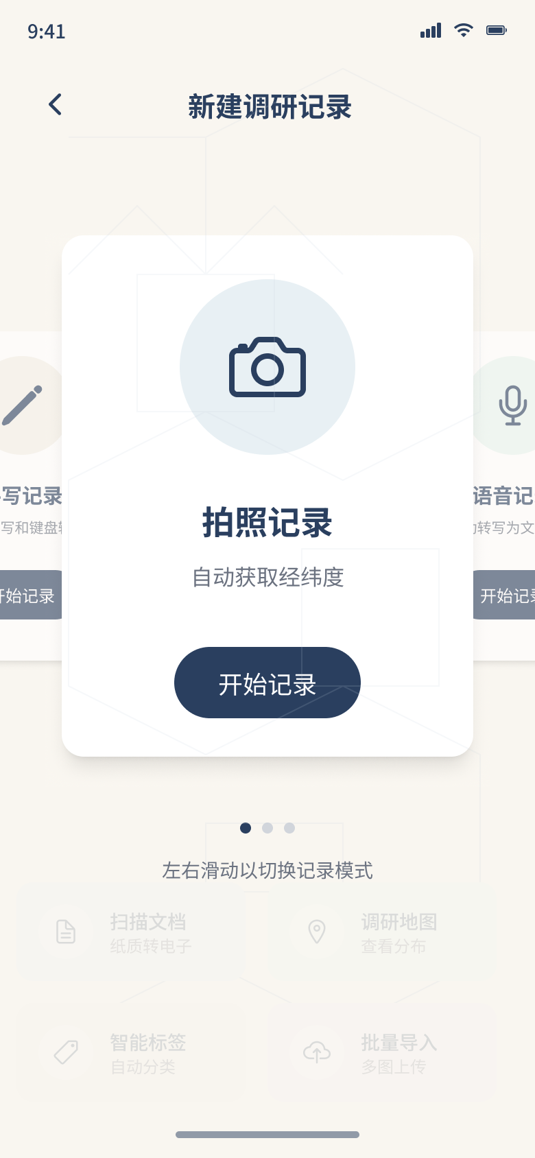
02. New Research Record
Instant voice/note/photo capture sheet with rapid pre-cached tagging.
03. Route Map
Continuous breadcrumb telemetry trail with pinned media flags anchored along track.
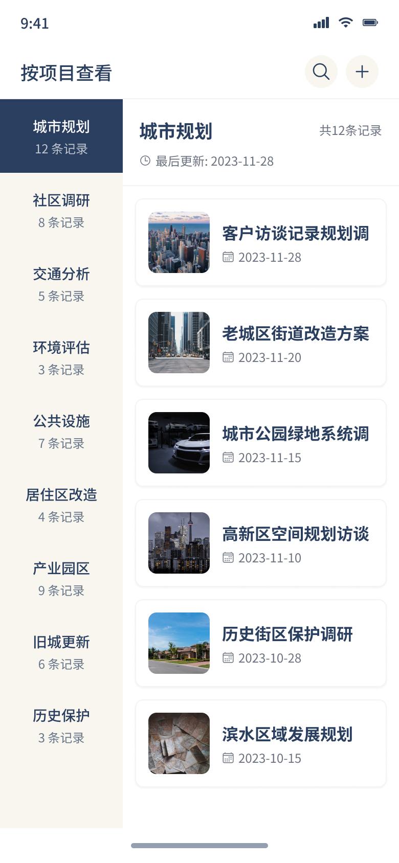
04. Project Browser
Hierarchical site directory, status chips, team synchronization indicators.

05. Date Browser
Chronological research timeline paired with ambient weather and site context.
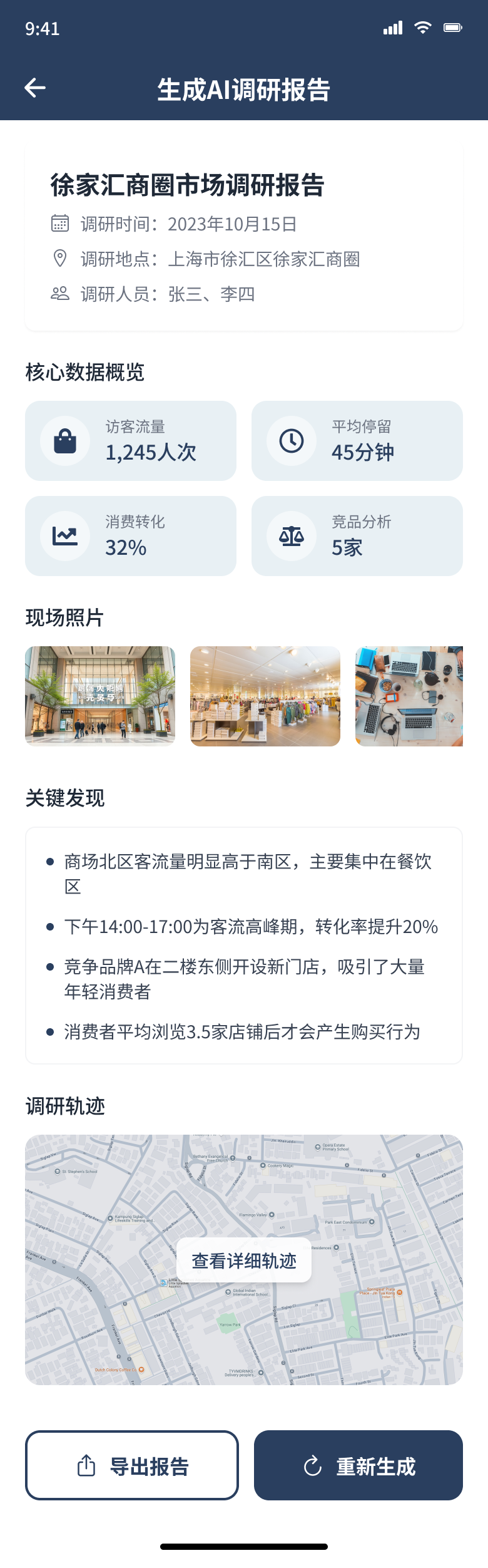
06. Record Detail
Complete multimedia dossier, spatial coordinates, EXIF parameters, and annotations.
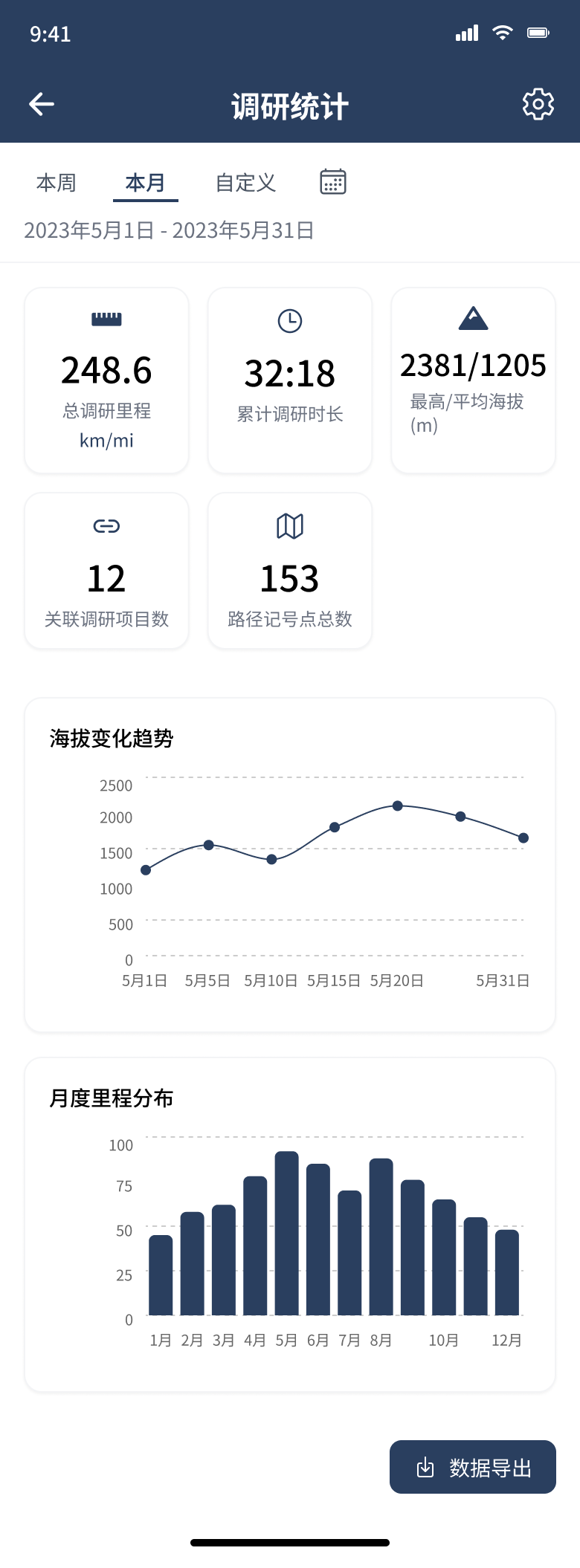
07. Statistics
Spatial distance covered, waypoint density, and media audit counts for billing.
A design structure reflected in the implementation.
The working version uses SwiftUI with MVVM and Router patterns. Models, ViewModels, Views, Services, and Components are separated so navigation, state handling, and data logic remain maintainable.
CoreData & SwiftData
Raw entity schemas, migrations, local persistence.
ObservableObject
State encapsulation, async fetch, intent dispatch.
Declarative DSL
Composable pure SwiftUI views binding to state.
Hardware Subsystems
CoreLocation manager, AVFoundation audio engine.
Design Tokens
Buttons, chips, metric badges, map card views.
Declarative Reactive UI
State and binding guarantees that field updates instantly invalidate affected child views without manual notification subscriptions.
Decoupled AppRouter
Navigation paths are modeled as exhaustive Swift enums, allowing programmatic cross-linking between map waypoints and project dossiers.
CoreLocation Background Service
High-accuracy telemetry uses deferred location updates to preserve battery during continuous 6-hour field surveys.
Project Deliverables
The project produced a functioning native product structure that connects field capture, location, media, routes, browsing, and statistics within a single professional workflow.
Shipped TestFlight Build
Functional native iOS application deployed to 12 active planning consultants in Shenzhen and Hong Kong for real-world municipal surveys.
Tokenized Design System
Production Asset Catalog containing typography tokens, adaptive color spaces (P3 wide gamut), spacing multiples, and semantic icons.
Field-Tested Ergonomics
Validated one-handed interaction reachability zones on iPhone 15 Pro, allowing 100% of standard capture operations without second hand assistance.
Reflection & What's Next
What the Research Proved
Structuring the product around the project rather than loose files fundamentally solves the post-visit synthesis hurdle. Field consultants reported saving between 90 and 150 minutes per field day simply by eliminating manual coordinate-to-photo matching upon returning to office desktops.
Areas for Future Exploration
- arrow_forward Peer-to-Peer Ad-Hoc Sync: Testing MultipeerConnectivity for zero-cellular deep wilderness and underground infrastructure surveys.
- arrow_forward GIS Export Bundles: Client-facing one-click export packages into standardized GeoJSON, Shapefile, and structured PDF survey dossiers.
- arrow_forward Spatial Audio Transcription: Automated on-device Apple Speech-to-Text tagging to transcribe field conversations directly into searchable waypoint metadata.
SONX: Data-Intensive Analysis Product
Multi-step street-network acoustic telemetry, sensor mesh ingestion, and computational resilience analysis for urban municipal authorities.